

Scott Jasechko1,11 ✉, Hansjörg Seybold2,11, Debra Perrone3,11, Ying Fan4 , Mohammad Shamsudduha5 , Richard G. Taylor6 , Othman Fallatah7,8 & James W. Kirchner2,9,10
Groundwater resources are vital to ecosystems and livelihoods. Excessive groundwater withdrawals can cause groundwater levels to decline1–10, resulting in seawater intrusion11, land subsidence12,13, streamfow depletion14–16 and wells running dry17. However, the global pace and prevalence of local groundwater declines are poorly constrained, because in situ groundwater levels have not been synthesized at the global scale. Here we analyse in situ groundwater-level trends for 170,000 monitoring wells and 1,693 aquifer systems in countries that encompass approximately 75% of global groundwater withdrawals18. We show that rapid groundwater-level declines (>0.5 m year−1) are widespread in the twenty-frst century, especially in dry regions with extensive croplands. Critically, we also show that groundwater-level declines have accelerated over the past four decades in 30% of the world’s regional aquifers. This widespread acceleration in groundwater-level deepening highlights an urgent need for more efective measures to address groundwater depletion. Our analysis also reveals specifc cases in which depletion trends have reversed following policy changes, managed aquifer recharge and surface-water diversions, demonstrating the potential for depleted aquifer systems to recover. Groundwater is the primary water source for many homes, farms, industries and cities around the globe. Unsustainable groundwater withdrawals and changes in climate can cause groundwater levels to fall1–10, making groundwater resources less accessible17. Global maps of groundwater storage trends are available7 from the Gravity Recovery and Climate Experiment (GRACE) satellites, although at a resolution that is too coarse (>150,000 km2 ; ref. 19) to detect local changes and inform local management. Measuring multidecadal groundwater-level declines and managing their consequences—including seawater intrusion11, land subsidence12,13, streamflow depletion14–16 and wells running dry17—requires in situ groundwater-level measurements from networks of monitoring wells. Such monitoring-well networks have been used at local and regional scales to estimate groundwater recharge20,21, characterize streamflow depletion14, evaluate the risk of wells running dry17 and test whether surface-water diversions22,23 or market and policy interventions24 have succeeded in slowing groundwater losses. However, in situ groundwater-level observations have rarely been analysed at the global scale because we lack a global compilation of in situ groundwater-level time series. Here we compile and analyse in situ measurements of groundwaterlevel trends in about 170,000 monitoring wells. The measurements provide new constraints on the prevalence of rapid and accelerating groundwater-level declines and their correlation with land use and climatic drivers. Furthermore, the measurements highlight individual cases in which groundwater levels have recovered following policy changes25 and inter-basin water transfers26. Local hotspots of groundwater-level changes We compiled and quality-controlled groundwater-level time series in monitoring wells from more than 40 countries (see Methods and Supplementary Notes 1 and 2).
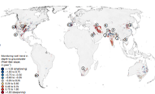
We calculated twenty-first century trends in depth to groundwater level for about 170,000 monitoring wells with time series that span at least 8 years using Theil–Sen robust regression (Fig. 1; analyses based on alternative regression techniques and on different quality-control thresholds yield similar results; see Supplementary Notes 3, 4, 5 and 6). Positive Theil–Sen slopes indicate deepening groundwater levels (red points in Fig. 1). Trends in groundwater levels often differ substantially from well to well, and local hotspots of groundwater decline can be found even in regions in which nearby groundwater levels are stable or rising, and vice versa (Fig. 1), highlighting the importance of analysing groundwater-level trends at the scales defined by the boundaries of individual aquifer systems.
to read the full article please click on
/wp-content/uploads/2026/07/Rapid%20groundwater%20decline%20.pdf
^
Scott Jasechko1,11 ✉, Hansjörg Seybold2,11, Debra Perrone3,11, Ying Fan4 , Mohammad Shamsudduha5 , Richard G. Taylor6 , Othman Fallatah7,8 & James W. Kirchner2,9,10
Groundwater resources are vital to ecosystems and livelihoods. Excessive groundwater withdrawals can cause groundwater levels to decline1–10, resulting in seawater intrusion11, land subsidence12,13, streamfow depletion14–16 and wells running dry17. However, the global pace and prevalence of local groundwater declines are poorly constrained, because in situ groundwater levels have not been synthesized at the global scale. Here we analyse in situ groundwater-level trends for 170,000 monitoring wells and 1,693 aquifer systems in countries that encompass approximately 75% of global groundwater withdrawals18. We show that rapid groundwater-level declines (>0.5 m year−1) are widespread in the twenty-frst century, especially in dry regions with extensive croplands. Critically, we also show that groundwater-level declines have accelerated over the past four decades in 30% of the world’s regional aquifers. This widespread acceleration in groundwater-level deepening highlights an urgent need for more efective measures to address groundwater depletion. Our analysis also reveals specifc cases in which depletion trends have reversed following policy changes, managed aquifer recharge and surface-water diversions, demonstrating the potential for depleted aquifer systems to recover. Groundwater is the primary water source for many homes, farms, industries and cities around the globe. Unsustainable groundwater withdrawals and changes in climate can cause groundwater levels to fall1–10, making groundwater resources less accessible17. Global maps of groundwater storage trends are available7 from the Gravity Recovery and Climate Experiment (GRACE) satellites, although at a resolution that is too coarse (>150,000 km2 ; ref. 19) to detect local changes and inform local management. Measuring multidecadal groundwater-level declines and managing their consequences—including seawater intrusion11, land subsidence12,13, streamflow depletion14–16 and wells running dry17—requires in situ groundwater-level measurements from networks of monitoring wells. Such monitoring-well networks have been used at local and regional scales to estimate groundwater recharge20,21, characterize streamflow depletion14, evaluate the risk of wells running dry17 and test whether surface-water diversions22,23 or market and policy interventions24 have succeeded in slowing groundwater losses. However, in situ groundwater-level observations have rarely been analysed at the global scale because we lack a global compilation of in situ groundwater-level time series. Here we compile and analyse in situ measurements of groundwaterlevel trends in about 170,000 monitoring wells. The measurements provide new constraints on the prevalence of rapid and accelerating groundwater-level declines and their correlation with land use and climatic drivers. Furthermore, the measurements highlight individual cases in which groundwater levels have recovered following policy changes25 and inter-basin water transfers26. Local hotspots of groundwater-level changes We compiled and quality-controlled groundwater-level time series in monitoring wells from more than 40 countries (see Methods and Supplementary Notes 1 and 2).
We calculated twenty-first century trends in depth to groundwater level for about 170,000 monitoring wells with time series that span at least 8 years using Theil–Sen robust regression (Fig. 1; analyses based on alternative regression techniques and on different quality-control thresholds yield similar results; see Supplementary Notes 3, 4, 5 and 6). Positive Theil–Sen slopes indicate deepening groundwater levels (red points in Fig. 1). Trends in groundwater levels often differ substantially from well to well, and local hotspots of groundwater decline can be found even in regions in which nearby groundwater levels are stable or rising, and vice versa (Fig. 1), highlighting the importance of analysing groundwater-level trends at the scales defined by the boundaries of individual aquifer systems.
to read the full article please click on
/wp-content/uploads/2026/07/Rapid%20groundwater%20decline%20.pdf
^
