
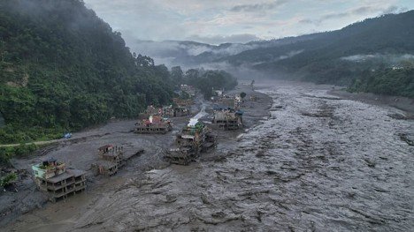

Hydrological experts piece together what happened as new evidence emerges from Nepal’s Rasuwa Floods.
September 1, 2026 | By Santosh Nepal
In the wake of Nepal’s catastrophic flash floods, to those who have lost homes and loved ones: your grief is witnessed, your resilience commands respect and your recovery is a global moral imperative. Urgency, empathy and unwavering solidarity must define our response.
The August 26, flash floods in China and Nepal in the Langtang mountain region are a devastating reminder of how rapidly hazards can cascade across the Himalayas.
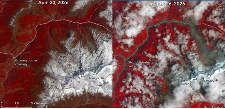
Before and after Landsat images of the glacier detachment and debris flow path from the north of Langtang Himal. Photo: Landsat – MyRepublica
Preliminary analysis suggests that the disaster was triggered by a glacier–rock avalanche in the Langtang Himal, generating a high-energy debris flow and flood that travelled downstream through the Bhote Koshi–Trishuli river system. As the flood moved downhill, it picked up additional soil, glacial deposits, sediment and large boulders, becoming extremely destructive. The huge mass then reached the Lhende River near the Nepal-China border. From the initial detachment zone to the Lhende River valley, the materials had travelled nearly 2,000 meters. During this time, rapid melting must have occurred due to gravitational fall impacts and temperature differences.
Glacier collapse area in the northern part of Langtang Himal, within Nepal. The upper circle is where the glacier detached and lower circle is where the glacier mass and debris reached the Lhende River. Graphic: Santosh Nepal adapted from Google earth
The collapse generated strong seismic waves of 5.2 magnitude, recorded at around 8:37 a.m. Within just seven minutes, the flood reached the border checkpoint and engulfed buildings within seconds. During that process, the flood and debris flow travelled at a speed of about 170 kilometers per hour. In simple terms, it was a chain reaction: rock ice avalanche, landslides, debris flow and then a devastating flash flood. This was a cascading disaster of unprecedented scale.
As highlighted in the IPCC Special Report on the Ocean and Cryosphere in a Changing Climate, glacier retreat and permafrost thaw are reducing the stability of mountain slopes. Rising temperatures accelerate snow and ice melt, allowing meltwater to infiltrate into glaciers and fractured underlying bedrock, potentially weakening slope stability. Repeated thawing and freezing cycles may further contribute to the progressive destabilization of rock masses. More investigation is required to determine the extent to which long-term climate change and recent climatic extremes contributed to this disaster.
This was not the first damaging glacial event to strike the region: 14 months ago, a glacial lake flood killed dozens of people, destroyed the China-Nepal border bridge and a few hydropower plants downstream — highlighting the region’s continued vulnerability.
At the time of writing, these observations remain preliminary. Important questions still need scientific investigation, including the volume and velocity of the flood wave, the role of rapid ice melt and how temporary river blockage and sudden release amplified downstream flooding.
As of September 1, the death toll from the flooding has risen to over 900, while hundreds of people remain missing including tourists and travelers. Many were making an auspicious pilgrimage to the alpine lake of Gosaikunda for Janai Purnima, a sacred full moon festival where people tie protective threads. The full scale of loss and damage is not yet known, but reports show that several major settlements and critical infrastructure have been swept away.
Furthermore, the Ministry of Energy, Water Resources and Irrigation (MOEWRI) indicates that nine operational hydropower projects with a combined capacity of 359 megawatts (MW) and five projects under construction with about 395 MW have been severely affected. This single event has impacted nearly 10% of the country’s current hydropower production.
Cascading disasters are on the rise, compounding risks and impacts across the region
A cascading disaster occurs when one hazard triggers a chain of subsequent hazards and impacts, amplifying the consequences of the overall disaster. Climate change is increasing and intensifying cascading hazards particularly involving glaciers, landslides, debris flows and flash floods.
The 2021 Melamchi flood in Nepal and the Sikkim disaster in 2023 demonstrate how floods, debris flow, landslides, lakes and glaciers can interact to amplify impacts across the Himalayas. The Melamchi catastrophe emerged from an intersection of human activities and climate variables, unfolding across various geographical segments of the river basin, while in South Lhonak Lake in Sikkim, India, a glacial lake outburst caused floods and sediment displacement that resulted in substantial loss of life and economic damage.
In February 2021, a rock and ice avalanche of similar nature to Rasuwa occurred in the Chamoli region of India. While the Rasuwa flood is more severe, in Chamoli too, the rock and ice avalanches triggered flash floods and caused massive damage to downstream areas. The glacier breakage and ensuing floods in Chamoli killed more than 200 people and destroyed two major hydropower facilities. Extreme events combined with a warming climate could increase both the frequency and severity of mountain hazards in the future.
How do we mitigate against cascading disasters in the long run?
As Nepal looks to rebuild after this catastrophic flood, it is important to examine long term plans on how we can strengthen our disaster preparation and early warning systems.
Strengthen country level multi-hazard risk assessments. Climate change and increasingly frequent, extreme natural events are creating conditions not seen in historical records. Traditional rainfall-based forecasting alone is no longer sufficient — as seen in the Rasuwa flash floods where no extreme rainfall was recorded immediately before disaster struck. Risk assessments should consider multiple hazards, including rainfall but also landslides, rock and ice avalanches, glacier-related hazards, debris flows and temporary river blockage and sudden release.
Address and mitigate the cascading nature of mountain hazards. Greater attention is needed to understand how different hazards interact and trigger cascading disasters in mountain contexts. A localized event in high mountain areas can rapidly create severe impacts in the downstream areas. Risk assessments should therefore examine the complete chain of hazards and their potential consequences.
Update and strengthen monitoring and early warning systems. Potential risk zones should be identified and monitored proactively using satellite observations, remote sensing, field investigations and other available technologies. Early warning systems should integrate multiple sources of information and provide timely warnings to downstream communities and infrastructure operators. Such warnings should be disseminated in local languages to ensure no one is left behind.
Strengthen transboundary cooperation and infrastructure resilience. Timely sharing of hydrological, meteorological, geological and satellite information across borders is critical for improving risk assessment and early warning. The governments of Nepal and China agreed to share real-time weather data after the Rasuwa flood. However, in the longer run, a constant, formalized mechanism to share real-time data between countries would be invaluable.
Critical infrastructure development to consider long term exposure to natural hazards. From the planning stage, hydropower plants, roads, bridges and other critical infrastructure should be designed with exposure to multiple and cascading hazards in mind, rather than relying solely on conventional standards such as a 50-year return period flood. Future investments must account for climate risk, changing hazard conditions and cascading nature of disasters so that these risks are perceived before designing the infrastructure and development activities.
The flash flooding on August 26, 2026 in Nepal, has left communities along the Trishuli River covered in mud and debris. Photo: Rajesh Kumar Singh/AP Photo
Natural disasters are never fully preventable, particularly as climate patterns are increasingly more volatile. However, combining mitigation and adaptation efforts can help reduce the scale of damage and ensure those most vulnerable to climate disaster are given adequate support.
As a research organization working on water security and resilience across the global south, with offices in Nepal, the International Water Management Institute (IWMI) remains committed to supporting the Government of Nepal and its partners through science, evidence and expertise that can contribute to a better understanding of water-related risks and strengthen preparedness and resilience for the future.
Source:https://www.iwmi.org/blogs/a-warning-from-a-changing-himalaya-on-the-growing-risk-of-cascading-disasters/
